|
|
 |
| |
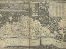
Hollar map of London after Fire 1667. It shows the extensive devastation caused by the Great Fire and includes an image of the conflagration in an inset panel. |
Peter’s cartographical curiosities of the capital
Maps tells us just as much about history as about places, British Museum curator
Peter Barber tells Dan Carrier
London: A Life in Maps.
24 November 2006 – 4 March 2007.
The British Library, Euston Road.
AS you walk over the crest of Parliament Hill and head towards the Hampstead Ponds, there is a thick set hedgerow on your left. It may look like any other hedgerow on the Heath – but this hedgerow has history.
And as a new exhibition at the British Library shows, this hedgerow has been in situ for more than 1,000 years, and marked the boundaries of the Hampstead parish when the lands were granted to Westminster Abbey by the monarch.
The map is just one of thousands held by the British Library and makes up part of a new exhibition that traces the growth of London.
Finding 200 maps out of the huge collection for the autumn show was the job of curator Peter Barber, who lives in Parliament Hill and therefore the number of maps of the Camden area in his care hold particular interest.
Seventy-five per cent of the selection have never been seen in public before.
“Maps are not just about finding a route from A to B,” he says. “They reveal so much more than that – they tell us what people in the past found interesting, what people in the past found important.”
And the maps range from the more simple historical street plans to documents that were used for civic life – public health, businesses, the city’s infrastructure. All are included in the exhibition.
“The earliest map we have on show is a Roman one dating from 296 AD and the latest is one showing the projected works being done in London for the 2012 Olympics,” explains Mr Barber.
Other oddities include a map from the 1600s designed for use by those who often travelled into the centre of town from out lying villages, like Kentish Town and Hampstead.
“It was made for people who took cabs home to make sure they were not being diddled by their drivers,” explains Mr Barber. And others take the viewer back many centuries.
Kentish Town resident Dr William Stuckley – whom the street Stuckley Place is named after – was not only a doctor and a clergyman, but a keen archaeologist. He was one of the first people to consider the history lying under the expanding roads and buildings of London.
“He was convinced that Julius Caesar had a large camp on the site of St Pancras train station,” explains Mr Barber.
“So he set out to draw a map of it. It is a good piece of work. He was more interested in history than medicine or religion.”
Others of the King’s Cross and St Pancras area date form the 1880s – and detail the space that the British Library sits on now.
Mr Barber said: “This map was drawn up by a property speculator and it was he who drew up proposed roads and then inked in their names. There is a road to be built called Ossulston Street, which still exists today.”
One of the largest maps on display – standing 15 feet high – shows the Manor of St John of Jerusalem, which covers much of the south of Islington and was commissioned in 1834.
And the smallest map in the show also displays a stretch of Islington. Designed as a business card, it was made by map maker and engraver Thomas Sterling from the Essex Road area in 1800.
“All the important places of interest are marked on the map – and also his private home,” Mr Barber says.
There are not so many maps surviving from the Middle Ages, but this is partly because of the culture of the times, rather than a dearth of map making.
“Most maps of the time were religious and showed a wider view of the world, rather than being used as a guide of how to navigate. Back then, most people would ask for directions,” explains Mr Barber.
Some are more specialised. He says:“I have one which shows the distribution of Jewish people in East End in 1900, while another chronicles the outbreak of cholera in Stepney. I have another that proposes the route of the Euston Road, drawn up for the landowners, Mr Goodge, Mr Warren and Mr Pentonville – who all lent their names to streets which were eventually built. And then there is a Luftwaffe map showing areas their bombers were to aim for, with details of how to spot the Beckton gas works in the East End.”
With such a choice of interesting maps, Mr Barber had a tough decisions to make as to what to show.
He said: “There were two things I was really looking for,” he explains.
“I wanted to show how London had changed. But, almost more importantly, I wanted to show how people where thinking and how they were living through these maps. People only put on maps what they deem important at the time, and therefore if you study a map from a particular era, you can gauge what the prevalent ideas of the time were.
“London’s growth is outlined here as it battles through disease and fire, property booms and commercial expansion, war and comprehensive redevelopment. At the same time lesser known images enable you to see why and how these changes happened, and to catch a glimpse of Londoners’ lives and values, hopes and fears, and preoccupations and aspirations through the ages.
“Maps go beyond geography – they show the demographics of the city we live in too,” Mr Barber says.
|
 |
|
|
|
|
