|
|
 |
| |
Crime figures for the wards show a sharp rise in Hampstead Town. See below for figures |
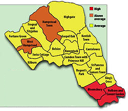
Met’s new crime map reveals the borough’s hot spots
Leafy suburbs of Hampstead show spike in crime figures that rivals the West End
THE Hampstead area has the highest crime in Camden outside the West End according to new police crime maps given a “low-profile” launch this week.
While Camden as a whole has average crime compared to the rest of London, West Hampstead and Hampstead Town wards are shown as high – alongside Holborn and Bloomsbury – on the new Met system which went online on Thursday.
The maps, based on figures for June, prompted an instant call for resources to be redirected to meet the real threats.
Chairman of the Hampstead Safer Neighbourhoods Panel Nigel Steward called for reinforcements to the six-strong community police team in Hampstead.
“I have always been aware that Hampstead is a significant crime ward,” he said. “It just goes to show that the Safer Neighbourhoods team cannot do it all on their own – that’s something I’ve been trying to get across for years, but I don’t feel I have been believed.”
Bloomsbury councillor Fazlul Chowdhury said the figures were “very surprising – only because the council keeps telling us that there is no problem in Bloomsbury and that all the resources should go to Camden Town.”
He added: “There should definitely be a shift of resources, and without delay.”
The launch of the maps, which some fear will effect house prices, was deliberately kept low-profile.
An internal police circular briefed staff not to discuss it with the press, stressing that it was “the test version of the new crime mapping website, and whilst it will be in the public domain we do not wish to have any formal press announcements”.
But the maps appeared on a Met test site last Thursday, and could change the way the authorities tackle crime, as the council’s community safety chief, Councillor James King, acknowledged on Tuesday.
He said: “As we delve into that data it might make us reassess some instinctive decisions that might not have been evidence-based.”
Both the council and the police have spent the past 18 months piling massive resources into Camden Town’s drugs market which, like King’s Cross in previous years, is believed to fuel crime across the borough.
But the maps would be welcome, Cllr King added, if they “encouraged local people to set priorities for their local area”.
Only the crimes of robbery, burglary and motor vehicle crime have been included so far, but, for the first time, the map shows detail of crime trends at the level of a few streets – known as “sub-wards” – in a colour-coded scale from low to high levels of crime.
Among the hotspots shown up by these maps are the notorious “frontline” along Camden High Street, and the section of West Hampstead south of Lymington Road, between Finchley Road and Frognal railway station and Finchley Road Tube, a stretch where residents have long campaigned for CCTV to combat robbers.
But some other areas which have traditionally been associated with crime actually show up as “cold spots” of very low crime. The Rowley Way estate in Kilburn and the Kiln Place area of Gospel Oak were both low crime areas in June.
King’s Cross, once notorious, is shown as an area of only average crime on the maps. The vast numbers of visitors to the West End, however, help make crime in Bloomsbury, Holborn and Covent Garden among the highest in London.
Acting borough boss Det Supt Jeremy Burton said that the spikes in crime in the north of Camden were being tackled by extra patrols, and that robberies had nearly halved in the past year while his detectives were solving more burglaries than any other force in London.
He added: “The crime-mapping site is currently a trial and the information is only based for one month only; so far, for the month of June. Clearly, there will be a better overall picture in the coming months, when the site is officially launched.”
Crime figure comparison across the borough
| Ward number of crimes (robberies, burglaries and vehicle crimes) |
June
2008 |
May
2008 |
| Hampstead Town |
43
|
14
|
| West Hampstead |
39
|
36
|
| Camden Town with Primrose Hill |
28
|
31
|
| King's Cross |
17
|
19
|
| Bloomsbury |
49
|
39
|
Holborn
and Covent Garden |
53
|
55
|
|
 |
|
|
|
| |
| |
| |
|
|
|